 Hits
Hits

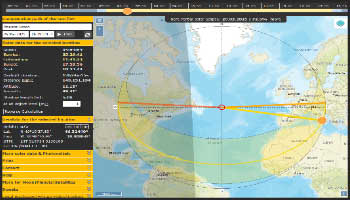
WXtrack Satellite tracking
- To predict the tracks of satellites both as paths above the earth, and as images produced by these satellites when scanning the ground
post 18 Jan 2025
Tracking Satellite Links →
Calculator for azimuth and elevation angle
Technology Calculators for azimuth and elevation angle
David Taylor Satellite tools
David Taylor's Weather Satellite programs, including signal demodulation and ground track prediction
DXSat
DXSAT is a satellite tracking program. It uses the lines of code and the DLL (djtsatlib.dll) made available to radio amateurs by David Taylor through his demonstration program
ERC are RS232- USB or LAN-interfaces
suitable to upgrade rotor-controllers which cannot be controlled by computers
56
Technology Calculators for azimuth and elevation angle
David Taylor's Weather Satellite programs, including signal demodulation and ground track prediction
DXSAT is a satellite tracking program. It uses the lines of code and the DLL (djtsatlib.dll) made available to radio amateurs by David Taylor through his demonstration program
suitable to upgrade rotor-controllers which cannot be controlled by computers
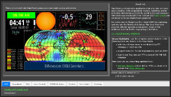
PSION Greyline Clock PSION Greyline Clock v. 1.0 is a UTC/Local clock showing sunlight/darkness area on the world map

Radioassistance Radioassistance E Kenwood Dealer, vendita ricetrasmittenti, antenne, parti di ricambio, elettronica
SunCalc SunCalc - sunrise, sunset, shadow length, solar eclipse, sun position, sun phase, sun height, sun calculator, sun movement, map, sunlight phases, elevation, Photovoltaic